GENERAL RESULTS
STONE AGE CRATHES
Uncovering one of the largest Mesolithic Sites in the UK
COLOUR
Buchan
flint
can
occur
in
a
variety
of
colours:
yellows,
reds
and
browns
predominate
at
Skelmuir
Hill,
whereas
medium
-
pale
grey
flint
is
dominant
at
Boddam
Den,
although
this
distinction
is
not
sufficient
for
allocation
of
a source.
The
main
colours
on
the
Crathes
site
are
brown,
yellow,
red,
orange,
grey.
However,
there
was
every
combination
in
between!
James
said
to
use
the
Mundol
charts,
but
I
soon
gave
up
on
this
as
there
were
variations
in
colour
in
most
pieces,
and
some
had
different
colours
e.g
brown
with
a
black
layer
under
the
cortex.
Some very general observations:
Whitish tended to be coarser grained and often opaque
Orange/brownish orange tended to be finer grained
Paler
grey
flints
tended
to
be
more
coarse
grained,
whereas
the
dark
grey/black
tended
to
be
finer
grained, some very dark/black was very fine grained, yet in thinner areas almost transparent.
Yellow:
much
of
the
initially
yellow
flint
became
much
browner
over
time
whereas
some,
of
a
richer
deeper yellow retained its colour.
Red, grey and whitish flint retained its colour
Suspect brown/yellowish brownmay become more orange-y over time?
In
the
end,
I
decided
to
use
T
Ballin’s
(2014)
basic
colour
classification
of
brown-yellow-orange,
red,
grey,
with
the
addtion
of
black
and
whitish
for
this
report.
Even
so,
this
assessment
has
to
be
subjective,
rather
than
objective:
eg:
deciding
whether
a
flint
is
brownish
grey
(ie
Grey)
or
greyish
brown
(ie
Brown)
is
not
always
easy. Flints designated as ‘whitish’ tended to be more whitish than pale grey.
As heat/burning can change the colour of the flint, only unburnt pieces were asessed.
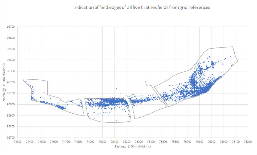
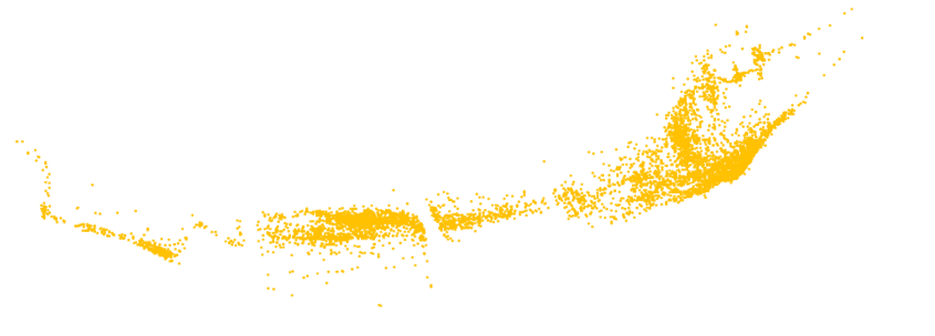
THE SCATTER
Although
the
scatter
(see
chart)
is
continuous
there
are
two
major
intensive
areas,
each
with
possibly
associated
sub-sites:
Nether Mills West: NM 1 extending into NM 2,
Nether Mills East: extending well into NM 4 and NM 3; includes the JBK dig site
Milton
Cottage:
less
intensive
and
could
well
extend
into
the
football
pitch
area,
bordered
by
the
Coy
Burn,
at the West. It may be a sub-site relating to NMW.
Consequently
I
refer
in
this
report
to
Nethermills
East
(NME),
Nethermills
West
(NMW),
and
Milton
Cottage
(MC)
as
being simple and logical, rather than the confusing and misleading array of names in Canmore and SMR.
(Nether
Mills
West:
previously
Durris
Bridge
(Canmore)
and
Crathes
Mains
(Abdnshire
SMR)
both
referring
to
the
same
collection.
Although
the
bridge
is
officially
the
Durris
Bridge,
this
collection
is
from
Crathes,
not
Durris,
is
at
the
north
edge of the field not near the bridge, and is from Nether Mills Farm not Crathes Mains.)
The
bulk
of
the
Nether
Mills
flints
were
found
along
the
middle
river
terrace
except
for
those
in
NM
1
on
an
‘island’
of
higher
ground
on
the
lower
terrace.
This
is
close
to
the
SW
edge
of
the
middle
terrace
and
seems
to
extend
into
the
E
edge
of
MC.
The
material
from
MC
was
mostly
on
the
higher
areas
along
the
river
bank
(ie
the
lower
terrace).
In
general
the
river
braiding
is
reflected
by
the
scatter
concentrations,
as
they
were
mostly
on
the
higher
ground in all five fields (see Google map below).
James
Kenworthy’s
excavation
was
situated
near
the
SW
corner
of
NM
4,
an
extremely
small
part
of
NME
let
alone
the
whole
of
the
Crathes
scatter.
The
concentration
at
the
major
site,
NMW,
is
more
intense
than
that
at
NME.
It
must
be
remembered,
however,
that
approximately
30,000
flints
were
removed
from
NME
during
James’
excavation.
LITHICS
The material
With the exception of two agate pieces and one anomalous piece, the assemblage was of flint.
This
siliceous
stone
was
attractive
to
prehistoric
people
because
it
can
be
worked
in
a
predictable
and
repeatable
way
to
produce
sharp
edges
and/or
to
manufacture
implements.
It
is
a
very
hard
material,
and
as
it
is
almost
indestructable,
the
presence
of
worked
flint
may
be
the
only
remaining
indication
of
prehistoric
activity.
Flint
pebbles
do
not
occur
in
the
River
Dee
(JBK,
Interim
Report)
and
James
referred
to
the
flint
found
at
Crathes
as
Buchan
flint.
Although
there
are
flint
mines
in
Buchan
at
Skelmuir
Hill
and
Den
of
Boddam,
associated
with
the
Neolithic,
it
is
thought
that
Mesolithic
people
(8000-4000BC)
made
use
of
beach
pebbles
along
the
coast,
and
surface
pebbles
in
Buchan
(D
R
Bridgeland
2000)

Five
years
of
fieldwalking
revealed
a
continuous
scatter
of
flints
through
the
five
fields:
1.75
km
along
the
river
bank
and
250m
to
the
north
in
the
widest
part,
one
of
the largest Mesolithic sites in the UK (Caroline Wickham-Jones 2016, page 50)
Table GR 1: Crathes: Presence/absence of types at each site

Type

MC

NMW

NME

Cores

yes

yes

yes

Meso broad blade microliths (larger)

yes

yes

yes

Meso broad blade microlliths (smaller)

yes

yes

no

Meso narrow blade microliths

yes

yes

yes
Meso microburins
no
yes
yes
Early Neo leaf-shaped arrowheads
no
yes
yes
Neo flaked knives
no
yes
yes
Neo ground and polished knife
no
yes
no
Scrapers
yes
yes
yes
Blades
yes
yes
yes
Flakes
yes
yes
yes
Split pebbles
yes
yes
yes
Possible Neo potsherd
no
yes
yes
For more details and definitions of types, see
Lithic Analysis
Table GR 2: Colour percentages from all unburnt flints at each site

Attribute \ Site

MC

NMW
NME

Total flints

711

4,543
4,638

Unburnt flints

509

3,331
3,747

% Brown

41.3

73.4
75.3
% Grey
39.3
14.2
12.6

% Red

6.9

7.4
8.7
% Whitish
10.7
4.5
3.1
% Black
1.8
0.5
0.3

% Pink

0.2

included with red
included with red
Table GR 3: Milton Cottage: Colour percentages from 2008 + 2011

Attribute \ Year

2008
2011
2008 + 2011

Total flints

206
505
711

Unburnt flints

169
340
509

% Brown

30.0
47.1
41.3

% Grey

51.8
33.3
39.3

% Red

7.1
6.8
6.9

% Whitish

10.7
10.6
10.7
% Black
0.6
2.4
1.8
% Pink
0.6
0.0
0.2
Table GR 4:Nethermills West, NM 2: Colour percentages from
2010 and 2011

Attribute \ Year

2010

2011

2010 + 2011

Total flints

294

478

772

Unburnt

230

346

576
% Brown
86.9
76.0
80.4
% Grey
6.1
9.0
7.8

% Red

4.3

10.7

8.2

% Whitish

2.6

3.5

3.1
% Black
0
0
0

% Pink

0

0.9

0.5
MC
NETHERMILLS WEST
NM 1
NM 2
NM 3
NM 4
NETHERMILLS EAST
MILTON COTTAGE
Milton Cottage (MC)
MC
CR 2011
Nethermills West (NME)
NM 1,1A
CR 2008
NM 2
CR 2011
Nethermills East (NMW)
NM 3,4
CR 2009


The scatterplot, showing the find-point grid references of lithics collected during the years 2008, 2009
and 2011. Field NM 1A is at the north of NM 1.
Even
during
fieldwalking
it
was
apparent
that
there
was
a
higher
proportion
of
grey
flint
at
MC
and
later
analysis
confirmed
this
(Table
GR
3).
However,
although
the
percentage
of
grey
flint
was
substantially
higher
than
that
of
brown
flint
in
2008,
in
2011
the
brown
flint
percentage
was
just
slightly
higher
than
that
of
the
grey (Table GR 3). The other colours, as with NMW and NME, were in smaller numbers (Table GR 3).
The
overall
percentages
of
brown
and
grey
flint
at
Nethermills
West
and
Nethermills
East
were
very
similar,
with
the
brown
flint
comprise
much
the
largest
group,
and
the
grey
a
poor
second.
Other
flint
colours
were
less
in
evidence.
Milton
Cottage,
however,
had
almost
equal
proportions
of
grey
flint,
(but
see
Table
GR
3
below). The remaining flint colours were in low numbers.
Burnt or not
Pieces
showing
crazing,
cracking
were
recorded
as
burnt,
whereas
those
with
red
tinges
were
recorded
as
slightly burnt. Several ‘pot-lids’ were picked up.
Burnt flint was found throughout the area, concentrations possibly reflecting the intensities of the scatters.
Numbers
may
be
an
underestimate
as
it
is
possible
that
flint
can
be
heated
with
no
noticeable
change
in
colour.
Heating
can
make
the
flint
easier
to
work,
but
I
am
not
aware
of
any
evidence
of
this
procedure
here
or
elsewhere on Deeside.
(This section is in preparation.)
For an overall site comparison the combined flint totals from each site were used to compile the percentages.
Table GR 2 comprises the flints from:
Milton Cottage: 2008+2011,
Nethermills West: NM 1 2008+2012 + NM 2: 2010+2011,
Nethermills East: 2009
Colour percentages at each site
Comparison of percentages in different years
In
2008,
Milton
Cottage
was
ploughed
late,
and
had
no
weathering
before
being
drilled
a
few
days
later.
Some
pieces
seemed
to
be
‘surface
stained’
by
the
surrounding
silty/sandy
substrate
colour,
and
some
even
seemed
to
have
a
very
thin
layer
of
substrate
strongly
adhering
to
the
surface
(James
said
they
looked
as
if
they
needed
a
good
scrub!).
I’ve
wondered
since
if
these
flints
had
just
been
unearthed
for
the first time, and they hadn’t been exposed long enough to be ‘cleaned’ by weathering?
The
percentage
of
grey
flints
was
lower
in
2011.
Maybe
any
staining/adhering
substrate
on
brown
flints
resulted
in
them
not
being
so
easily
discernable
in
2008,
but
not
all
flints
were
affected.
Nevertheless,
this
is a large difference between the two years!
Milton Cottage
(Still to be completed)
Reference
D
R
Bridgeland
(2000)
Flint-rich
gravels
in
Aberdeenshire,
in
The
Quaternary
of
the
Banffshire
Coast
&
Buchan,
Field Guide, edited by J W Merrit, E R Connell & D R Bridgeland. Quaternary Research Association, page 98.
The assemblage
During
the
process
of
tool-making,
many
waste
pieces
are
produced.
Where
large
scale
flint-knapping
has
taken
place, the resulting debitage can form the bulk of a collection, and this was certainly the case in Crathes.
Although
much
of
the
material
is
broken/damaged,
all
phases
of
manufacture
are
present,
from
the
preparation
of
the
raw
material
to
the
production
of
finished
tools.
Cores,
mostly
single
platform,
and
a
variety
of
scrapers
form
part
of
the
collection.
The
major
component
is
of
Mesolithic
technology.
Finds
diagnostic
of
the
Mesolithic
include
microliths
and
microburins,
with
the
‘broad
blade’
(possibly
earlier)
technology
represented
by
large
wide-based
triangles
and
oblique
points,
and
the
‘narrow-blade’
(possibly
later)
technology
by
crescents
and
backed bladelets. Three smaller wide-based triangles may be from an intermediate stage.
The
other
component
of
this
site
is
Neolithic.
Our
most
spectacular
find
was
a
very
fine
Middle
to
Late
Neolithic
ground
and
polished
knife.
Other
Neolithic
finds
include
two
small
flaked
knives,
four
Early
Neolithic
leaf-
shaped arrowheads (1 almost whole, 3 broken) and 2 small possible Early Neolithic potsherds (Table GR 1).
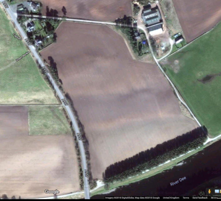


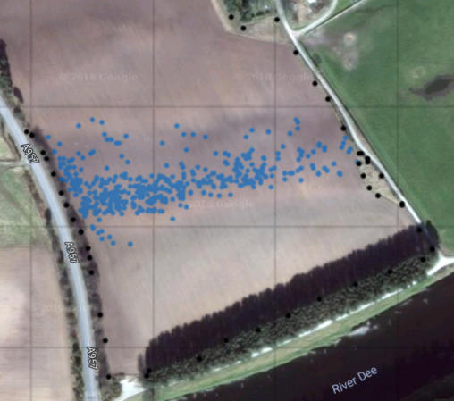
The black circles represent the grid references at edge of the field.
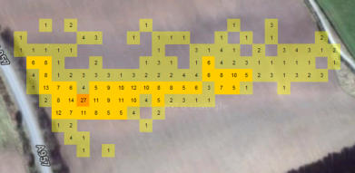
The
Google
map
shows
NM
2,
the
Field
Label
button
indicates
the
positon
of
the
terraces,
the
Scatterplot
button
shows
the
ditribution
of
the
flints,
and
the
Concentration
button
gives
the
number
of
flints
in
each
10m x 10m square, and the Most squares at the edges of the field extend beyond the boundaries.
The
scatter
is
almost
totally
confined
to
the
middle
terrace,
with
a
few
at
the
base
of
the
bank
and
a
few,
mostly at the east edge extending part of the way down the eroding edge of the middle terrace.