STONE AGE CRATHES
Uncovering one of the largest Mesolithic Sites in the UK
THE CRATHES SITE
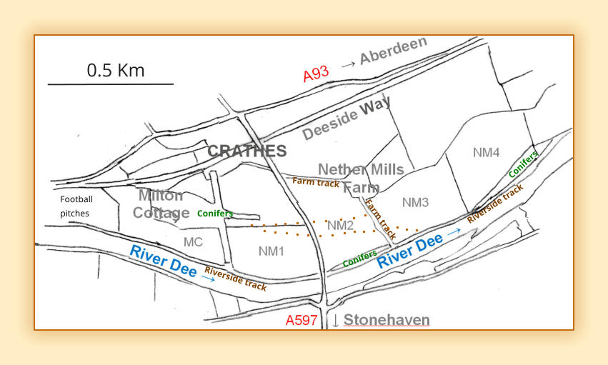
The brown dotted lines indicate the approximate edges of the three terraces.
The lower terrace (below the dotted lines, extends over MC, to the south-west corner of NM 3.
The
bank
of
the
upper
terrace
(above
the
dotted
lines)
extends
along
the
south
edge
of
NM
1A
into
NM
2,
and
peters out somewhat into a hillocky and pebbly area at the north of NM 3.
Between
the
two,
the
middle
terrace,
(approximate
location
between
the
dotted
lines
on
the
map)
widens
gradually towards the east becoming the river bank in NM3.
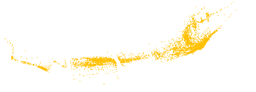
See ‘Google Map’ on the
General Results
page for an aerial photograph of NM 2 showing the terraces.
In
general,
the
middle
and
upper
terraces
are
quite
pebbly.
The
lower
terrrace
tends
to
be
more
sandy/silty,
with fewer pebbles. The south-east corner of MC is quite sandy.
The
middle
terrace
is
more
varied:
some
areas
are
more
silty,
especially
at
the
base
of
the
upper
terrace
in
field
NM
2
owing
to
downwash
from
the
bank,
with
some
areas
more
pebbly.
The
northern
part
of
NM
3,
where the ‘bank’ becomes less steep, and the northern edge of NM 4 are both very pebbly.
The
bank
of
the
upper
terrace
and
the
‘ridge’
is
quite
gravelly
and
pebbly
and
extends
further
east
beyond
NM
1A
ending
in
a
gravel
quarry.
On
the
other
side
of
the
north
wall
of
NM
1
(in
NM
1A)
some
lynchetting
has taken place, where the wall has prevented further downwash from the bank.
The
southern
edge
of
the
middle
terrace
is
slowly
eroding
as
a
result
of
ploughing,
especially
in
NM1
and
2.
During
our
fieldwalking
in
NM
2
it
was
noticed
that
a
gravelly/coarse
sandy
layer
was
exposed
at
this
edge,
presumably as a result of ploughing at a deeper level than had been done previously.
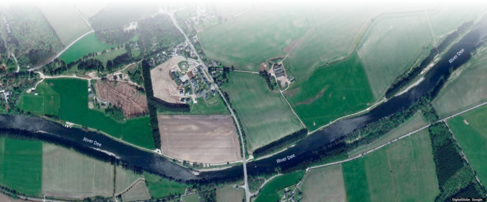
Site description
This
extensive,
predominantly
Mesolithic
site,
stretches
almost
2km
along
the
north
bank
of
the
River
Dee
at
Crathes, and is approximately 20 miles SW of Aberdeen, and 3 miles East of Banchory.
The
map
below
(from
OS
Explorer
406
Aberdeen
and
Banchory)
shows
the
area
around
Crathes.
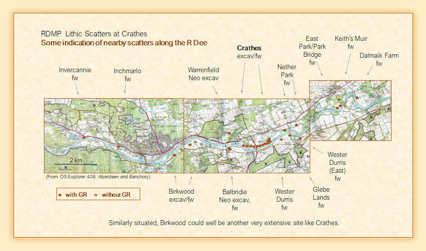
Locations
of
other
flint
scatters
nearby
derived
from
Canmore,
Aberdeenshire
SMR
and
personal
communications
have
been added.
The
sketch
map
below
shows
the
location
of
the
five
main
contiguous
fields
along
the
north
bank
of
the
river:
Milton
Cottage
(MC)
and
Nethermills
fields
1-4
(NM
1-4).
Field
Nethermils
1A
is
the
field
to
the
north
of
Nethermills field 1.
James
found
evidence
of
rig
and
furrow
in
his
excavation,
but
we
saw
no
visible
surface
signs
in
that
field
or
in
any of the others we looked at.
Victorian
pottery,
clay
pipe
fragments,
clay
marbles
and
small
earthenware
pots
were
found
in
all
the
Nethermills fields, but not in Milton Cottage field. Maybe this field was not ploughed until after the war?


